Note: A PDF file containing these Notes is available here.
We return to Briones Regional Park for the 31st Bay Area Scout Orienteering Championships and public event! All Scouts and non-Scouts are invited to attend, run a course, and have a generally good time! The forecast is for 60 degrees and 20% chance of rain until 10 AM, tapering to zero after that — great running weather. It is a good area for picnics, so bring your friends and your family and enjoy the park as well as the orienteering challenge. We will have some snacks for you to eat afterwards.
The Scout Orienteering Champs will be held in conjunction with a regular BAOC "local event" (aka "B-meet").
By order of the Park District: No smoking in Briones Regional Park.
Scouts must be pre-registered. Scout registration information can be found here.
Registration for the BAOC event can be done at the event from about 9:00 to noon.
The Courses
Here are the details for all the courses:
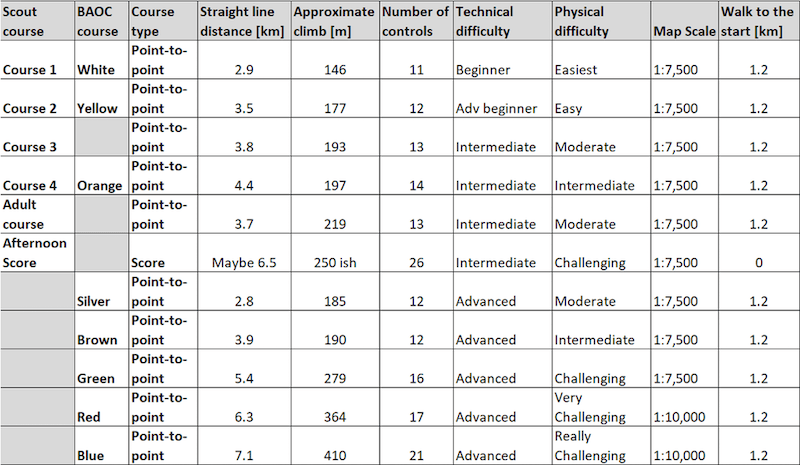
(If the table is too large for your screen, you can click on the table to see a smaller version.)
Note: The correct numbers of controls on the Advanced courses is 1 less than shown in the table above.
As shown in the table above, three of the Scout-O courses overlap BAOC courses: White(1), Yellow(2), and Orange(4).
The Map
There is a new map created by Bill Cusworth. It has 5 m contours, which are Lidar-based. Vegetation has been updated from the Lidar data. This map is a very nice improvement over prior versions!
All Courses
There is no water on the courses — please carry your own!
There is a steep down-slope towards the end of all the courses. A rope is available there to assist you in case your shoes are slippery.
Electronic punching with contactless SI-Air Beacon Mode is enabled. Please be sure to punch the "Check" unit to turn on your SI-Air (SIAC) finger stick, if you use one. The Finish unit turns off your Air stick.
Water features might be dry. The star thistle is patchy; nevertheless, long pants are recommended. Poison oak is minimal and avoidable. There are cows on the courses — they won't bother you, but don't get too close to the calves, or mama cows will get upset.
Advanced Courses
The courses are fast and open with typical climb (for Briones). The footing is good.
The Start and Finish
The Start for the morning BAOC and Scout courses is about 1.2 km from the assembly area — it takes about 20 minutes to walk there. Bring water!
The Scouts have pre-assigned start times — please be on time. For the BAOC courses, the earliest start is at 10:00; the latest start at 12:30.
The Finish is at the assembly area.
The afternoon Scout Score-O mass start will be between 1:00 and 1:15 PM near the Finish area.
Miscellaneous Comments
Please set a good BAOC example for the Scouts!
Remember that horses have the right of way, and try not to scare them.
Be polite to other park users please (this is a requirement for future permits).
Wildlife we have seen include deer, eagles, coyote, skunks, hawks, buzzards, orienteers, turkeys, goats, cows, salamanders, and frogs.
Driving Directions
The coordinates for the event are 37° 55' 37.5" N, 122° 09' 28" W (37.9271,-122.1578).
Registration will be at the West entrance to the park, off of Bear Creek Road. To get there, take Route 24 west from I-680 or east from I-580 or Hwy 13. Exit at Orinda (exit 9), heading north on Camino Pablo. After about 2 miles, turn right onto Bear Creek Rd. After about 3.5 miles, the park entrance will be on your right (it is well sign-posted).
(Don't be fooled by the parking area on the left before the park entrance. That's not it, but you could park there and walk if you like.)
Parking
The park has an entry/parking charge of about $4 per vehicle (and $2 per dog [Guide and Service dogs are free]), collected at the entry kiosk (if and when it's staffed).
Do not park in the south side of the east, dirt, parking lot. That area is reserved for horse trailers.