For this second day of the Tahoe 4-Day event, we will have a smaller selection of courses as event #4 of the seven-event BAOC 2025 Summer Series.
Everyone is welcome to participate in this event, including beginners and non-members. Free beginner instruction will be available during the time shown below. Participation on other Summer Series events is not required.
Note: Event #5 in the Summer Series will be on Monday, July 28, at Donner Lake Memorial Park. (The previous three events were in the Bay Area, as will be events #6 and #7.)
You can see a preview of the map at the top-right of this page (click on it for larger image). Perhaps you'll want to take your swimsuit on the course?
Overview
Three courses will be available for this event: a 2.5 km Beginner course; a 2.9 km, advanced, Short course; and a 5.1 km, advanced, Long course.
To avoid conflicts with ongoing construction work and the mountain bike park, and to utilize terrain that provides for good orienteering, the courses have been set in an area a bit higher up on the mountain than in years past. This location required us to place the Start approximately 700 meters from the mid-mountain station.
There are three options for getting to the Start, as described below.
Additionally, after you finish your course, there is a 1 km walk to the Assembly Area, where you'll download, socialize, and enjoy some snacks.
We appreciate your understanding of these adjustments, and wish you a great time on the mountain.
Schedule
The following non-standard event schedule will be followed. (Note that the schedule has been revised from what was previously given.)
  9:00 AM – 11:00 AM: Registration is open
  9:30 AM – 11:00 AM: Beginner instruction is available (free)
10:00 AM – 11:59 AM: Starts are open for all the courses
                  2:00 PM: Everyone must have returned to the Finish
Note: Participants under age 18 who register at the event must be accompanied by a parent or legal guardian, or bring with them a waiver signed by their parent or legal guardian. (The standard registration form is available here [12KB PDF]. Note, however, that some of the fees for this event are different than those on the form.) Note that you can register and start on the courses anytime during the open times above. Thus, for example, you do not need to be "punctual" at 9:00. (You can if you want, but please don't show up earlier and expect to be served.)
Beginner instruction is 15–20 minute, repeating sessions ("clinics") that introduce the sport of orienteering, and provide enough instruction to be able to complete the Beginner course.
Note: Beginners are given their course maps at registration. You should get your map before joining a beginner clinic. Everyone must return to the Finish by 2:00 PM, and then promptly go to the download tent, even if they have not completed their course. Please do not leave without checking in! If there are unaccounted people after 2:00, we must initiate a search for them.
Costs & Registration
Since this is a "special" event, the standard BAOC registration fees do not apply.
The prices for the Tahoe 4-day Package and for individual events are shown on the main Tahoe 4-Day event webpage. (Be sure to read the notes below the prices table.)
For this event, the Short and Long courses are considered "advanced" (although their navigation difficulty might be a bit easier than a "normal" advanced course).
Online registration closed at 6:00 PM PDT on July 23rd. However, registration for individual events (but not the Tahoe 4-day Package) will be available at the events.
Location of the Event
The Assembly Area (Registration and E-punch) will be located in the Northstar Village, as shown in this map:
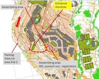
Driving directions to Northstar are below. We will park in area B or C in the Village View lot (see the map above and directions below).
Venue Facilities
There are restrooms, water, restaurants, and cafes in the village.
Restrooms are available in the Assembly Area and at the Middle Station (Big Spring Lodge) along the way to Start.
Some snacks will be available at the Assembly Area.
What to Bring
For the Beginner course, comfortable outdoors attire and shoes are fine.
For the Short and Long courses, the steeper hillsides can be a bit slippery due to dry leaves and loose dirt, so shoes with good grip are highly recommended. Long pants and/or gaiters might be desirable because of undergrowth.
A compass is not required, but can be very helpful — and can improve safety — so is recommended. We have compasses available for a $1 rental fee.
We time the courses with the SPORTident system, so each entry/team needs to have a SPORTident E-punch fingerstick. If you don't have your own, you can rent one at Registration for $5. (Use of the "E-punch" system is easy. You can learn how at the event, or read about it here.)
Courses
The course details will be available closer to the event date. For this Summer Series event, three courses will be available: Beginner, Short, and Long.
The Beginner course, which will be on trails, will be an excellent introduction to orienteering, with fantastic views as an added treat.
The Short and Long courses will venture off-trail and will require intermediate to advanced navigation. Their results will be included in the respective Summer Series competitions.
Note: Participation on other Summer Series events is not required, and you're free to ignore the "competitive" aspect of the Summer Series.
Breaking News:
To alleviate crowding on the Long course, a new course has been added to this event. Note, however, that this "Middle" course will not give you points toward your Summer Series rank.
If you want to change to this Middle course, see the people at registration.
Hazards
Fortunately, there is no poison oak in the Sierras! 😊
However, deer ticks are found in this area, and they might carry Lyme disease. So, please be sure to check yourself carefully after the event.
You should be mindful of dehydration because the high-altitude air will be dry. That concern will be even greater if the weather is hot. So, you should consider carrying water while on your course.
Also because of the altitude, there will be increased risk of sunburn, so be sure to use plenty of quality sunscreen.
Volunteers Needed
As always, we need volunteers for this event. We have these positions available:
Assembly Area Set Up: 8:00–9:00 (particularly appreciated 😉)
Registration: 9:00–11:00 (e.g., answering questions; any part of the period will be helpful)
Beginner Clinics: 9:30–11:00
Starts: 10:00–10:45, 10:45–11:30
Control Pickup: 2:00–3:00 (hopefully ending earlier)
Please consider volunteering to help — even part of a listed session will help! Previous experience is not needed (except for Beginner Clinics), and easy training will be provided as needed, so please don't hesitate to sign up.
You can check the form to see what's available, then send email to Göran Hellgren, the Event Director, or to Rex Winterbottom, the Event Coordinator, to indicate your interest or ask where they'd like help. The Event Director or Rex will respond back to you.
Driving Directions
Northstar California Resort is southeast of Truckee on Highway 267, between I-80 and Highway 28 (Kings Beach).
From eastbound I-80, take exit 188B for Sierraville/Lake Tahoe. From westbound I-80, take exit 188 for Lake Tahoe/Sierraville. After about 5.5 miles, turn right onto Northstar Dr. Follow the directions below to parking.
From the north shore of Lake Tahoe (e.g., Tahoe City, Kings Beach), at Kings Beach, head north on Highway 267. After about 6 miles, turn left onto Northstar Dr. Follow the directions below to parking.
Parking
Note: There will not be any BAOC signs leading you to the parking lot.
After 1.2 miles on Northstar Dr, turn right onto Big Springs Dr. After 0.4 mile, turn left into a large parking area. Continue about 0.5 mile down the hill toward the end of the parking area. Park in area C or B, before a sharp turn to the left.
Note: There's a slightly shorter route to parking, but it contradicts the large, red arrow in the map image above. 😉 Instead of turning right onto Big Springs Dr, continue 0.1 mile on Northstar Dr and turn right onto Currant Rd. Go up the hill and around to the left, where you will enter a long parking area — do not park there. At the end of that parking area there is a sharp, 180° turn to the right. Park after completing that turn. There is a Google map here that you can use to get driving directions. Or you can use these coordinates: 39.2754,-120.1235.
The map above shows the locations of the parking lot and Assembly Area.
The Assembly Area will be visible from the parking lot (but there will not be signs).